Topological
spatial
data,
linked
to
the
thematic
data
relating
to
vegetation
types
(flora,
ecology,
production),
are
managed
in
specific
layers,
all
of
which
are
derived
from
a
primary
layer
called
VEG4.
This
layer,
which
describes
the
boundaries
and
the
spatial
distribution
of
vegetation
types,
is
made
up
of
14
535
polygons,
which
are
areas
corresponding
to
the
various
vegetation
types
(with
the
exception
of
5
polygons
corresponding
to
open
water
-
the
minor
beds
in
Niger,
Bani,
part
of
the
Diaka
and
the
lakes
-
and
731
polygons
corresponding
to
built-up
areas).
Each
unit
is
made
up
of
a
polygon,
bearing
an
acronym
designating
its
vegetation
type
which may be a plant combination or a mosaic of plant combinations.
VEG4
,
the
essential
information
layer
in
the
GIS,
derives
directly
from
the
CIPEA/ODEM
rangeland
map
realized
by
Pierre
Hiernaux
and
Mark
Haywood,
who
also
played
a
key
role
in
the
realization
of
this
layer
of
GIS
information
by
performing
the
digitization
of
the
map
(30
sheets
40x25
cm
to
1:
100
000)
on
an
A3
format
digitizing
table,
using
the
drawing
software
programme
(Autocad).
These
maps
were
captured
within
a
5x5
km
squares
grid,
rigorously
using
the
method
developed
by
Mark
Haywood
for
the
realization
of
the
original
maps
constructed
on
a
UTM
grid
(spindle
30)
at
a
5
km
step,
each
digital
file
containing
six
5x5km
squares, usually arranged in a 3x2 format.
Mark
Haywood
was
also
careful
to
note
in
a
text
file,
for
each
polygon
with
a
recognition
mark,
the
unit
acronym
and
the
mark
coordinates
in
x
and
y.
This
file,
which
is
independent
from
the
163
DXF
graphics
files
that
represent
the
inland
Delta
rangeland
map
(approximately
978
squares
of
5x5
km),
contains
31,083
lines
(600
pages
of
word
processing).
This
data
base
entry
in
a
standard
exchange
format
(DXF
format)
cost
Mark
Haywood
three
years
of
work
and
greatly
facilitated
our
task.
However,
the
data
from
these
163
files
had
to
be
translated
into
a
single
ARC/INFO
layer
and
a
number
of
methodological
and
technical
problems
had
to be solved. For this we transcoded the 163 files into 163 ARC/INFO layers, then merged them into a single layer.
There
were,
however,
several
problems
to
be
solved:
a
unit
corresponding
to
a
vegetation
type
is
an
object,
therefore
it
must
be
represented
by
a
polygon.
However,
the
presence
of
the
construction
grid
could
lead
to
the
division
of
one
area
into
two,
three,
four,
or
more
adjacent
polygons
that
had
then
to
be
merged
back
into
a
single
polygon.
On
the
other
hand,
Autocad
does
not
allow
the
transfer
of
unit
attributes,
in
particular,
the
acronyms
identifying
the
vegetation
types.
To
do
this,
a
VEGPOINT
layer
was
created
from
the
text
file
including
the
x,
y
coordinates
and
the
acronym
of
the
labeled
point
inside
each
polygon.
We
therefore
had
a
layer
containing
all
the
arcs
i.e.
the
faces
of
the
future
polygons,
and
all
the
points
destined
to
become
the
labels
of
the
polygons
representing
the
vegetation
units.
Yet
it
was
imperative
to
have
one
single
label
per
polygon,
with
the
right
acronym
identifying
the
vegetation
type
of
the
polygon
(in
total,
31,083
points
and
as
many
elementary
polygons).
The
position
and
the
acronym
of
31,083
points
then
had
to
be
checked,
a
process
which
took
several
months,
and
the
adjacent
polygons
bearing
the
same
acronym
were
aggregated to get the final layer (Veg1).
From VEG1 to VEG4: simplifying thematic information
VEG1
contains
14,605
polygons,
each
identified
by
an
identification
number
(ID)
and
an
acronym
referring
to
its
vegetation
type,
i.e.
a
total
of
209
different
acronyms,
and
a
number
indicating
the
occurrences
of
the
acronym.
A
number
of
these
abbreviations
are
"script"
errors
made
when
drawing
maps
in
Addis
Ababa.
For
example,
the
acronyms
“TA/Z”
or
“TD/B”
indicate
mosaics
that
do
not
exist.
In
some
cases,
a
particular
unit
is
given
two
acronyms
representing
the
same
vegetation
type,
one
belonging
to
the
inland
Delta
nomenclature
and
the
other
to
the
nomenclature
used
in
the
«dead
Delta»,
for
which
another
vegetation
map
was
drawn
(and
has
remained
unpublished)
...
On
the
other
hand,
some
of
the
mosaics
are
ecologically
"unlikely"
and
are
only
represented in very few occasions : 35 mosaics are represented only once, 19 only twice, and so on.
In
general,
we
considered
that
all
mosaics
represented
in
10
units
or
less
should
be
replaced
by
the
ecologically
closest
mosaic.
This
transformation
also
extended
to
mosaic
considered
unlikely
although
present
in
more
than
10
units
(VSP/P,
AG/TT,
BP/B).
Finally,
the
TB/TC
mosaic
(made
of
two
dry
woody
savannas
on
“
togge
”,
very
close
to
one
another),
indicated
in
95
units,
was
simplified
as
TB.
The
TB/TC
mosaic
was
attributed
to
“TOPO”
units,
which
represent
the
built-up
area.
This
convention
makes
it
possible
to
suppress
“TOPO”
from
the
vegetation
map
(by
replacing
it
with
a
strongly
anthropized
woody
savanna
TB/TC
without
losing the polygons which can at any time regain their status as built-up surfaces.
Table 1 :


Ultimately,
we
retained
121
vegetation
types
(including
RIVER
which
represents
open
water
and
TB/TC
that
represents
built-up
areas).
The
acronym
modification
leading
to
the
121
vegetation
types
is
a
large
simplification
(from
209
to
121
vegetation
types).
However,
the
resulting
loss
in
spatial
information
is
very
limited,
with
a
reduction
in
number
of
polygons
from
14,605
to
14,535.
This
final
layer
is
called
VEG4
and
becomes
the
main
layer
of
the
GIS.
It
has
two
functions:
1)
to
document
the
spatial
distribution
of
the
vegetation
types;
2)
to
produce
derived
layers,
FLORE1
for
flora,
CRUE
3
for
ecological
data,
SOIL
for
soils
data
and
PRODUCT
for
rangeland fodder production.

F
i
gure
n° 1 :
The process leading to the organization of ARC/INFO covers to create VEG4
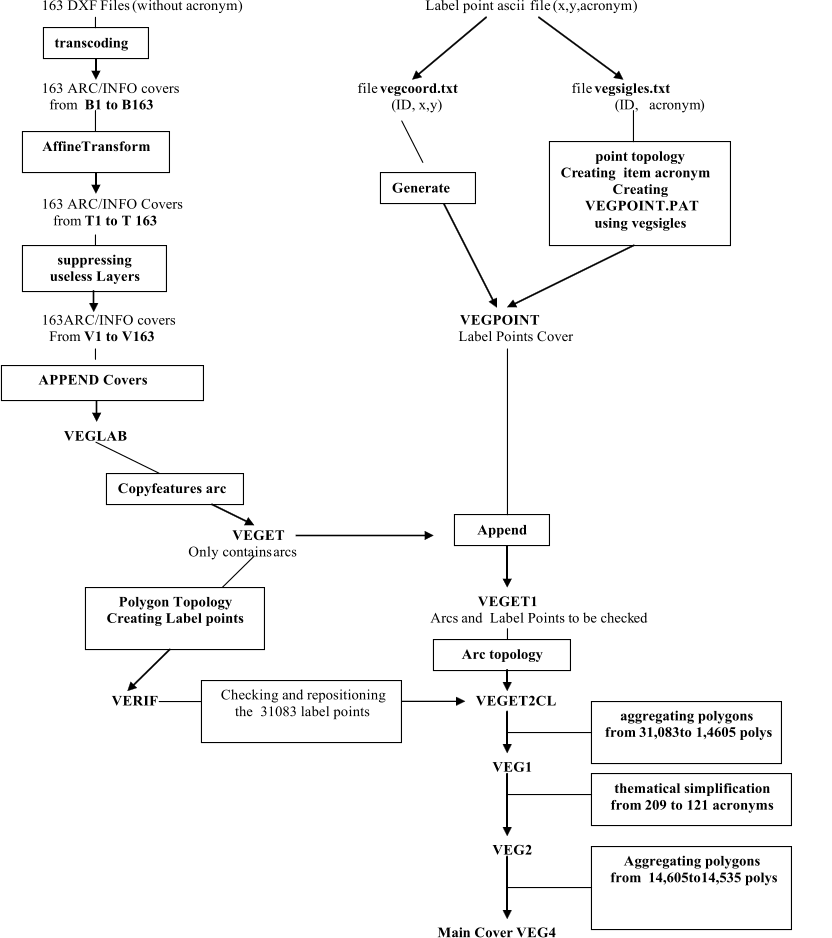


GIS organization (1)
SPATIAL DATA CREATION